Venerable Old Man Mountain — The Mist and Mystery of Okina-san (Mt. Okina)
おきなさん
翁山
OKINA-SAN
Legends and landscapes on an epic hike along the Ou Mountains
Obanazawa City, Yamagata prefecture, a location known for world-famous Ginzan Onsen. Yet on a lesser known side of Obanazawa is another spiritual powerhouse, one that epitomises the mist, mystery, and mystique of mountains in Japan, Okina-san, AKA venerable old man mountain.
A short 20 minutes north of Ginzan Onsen lie the rice terraces of Myokoji. Hidden behind this humble hamlet on the outskirts of Obanazawa, the intrigue of Okina-san means not only is it a 100 famous mountain of Yamagata, it is also one of the 100 famous mountains of Tohoku, a region encompassing the entirety of the northern part of Honshu.
The Ou Mountains
Okina-san is but one of the many peaks along Japan’s longest mountain range; The Ou Mountains that span the 500km length of the entire Tohoku region. Historically, the Ou mountains have been one of the biggest obstacles for travellers in Tohoku. However, for the likes of Haiku poet Matsuo Basho, the width of only 35km definitely helped things a bit. And much like Matsuo Basho’s legendary crossing of the Ou Mountains compiling Oku no Hosomichi (The Narrow Road to the Deep North), Okina-san’s namesake is also the stuff of legend.
Exactly how did this peak come to be known as venerable old man mountain? And has it always been that way?
In short, no.
According to The Vicissitudes of Myokoji, Okina-san started out as Hoju-mine. However, a chance encounter, or, should I say, two encounters, led to the mountain receiving its now epic name.
Okina-san is known for:
- Name that is literally the stuff of legend
- Fun loop trail with expansive views to boot
- One of the 100 Famous Mountains of Tohoku
- Located along the Ou Mountains, Japan's longest mountain range
The Legend of Venerable Old Man Mountain

One day, a hermit named Myoken was out hunting birds and game near his hermitage on Hoju-mine when all of a sudden he spotted a single white deer in the distance. The deer stared at Myoken intently, as if to say ‘come with me’.
Enthralled by the very sight, Myoken quickly slid his bow and arrow back into its sheath, and began the chase; cutting through the deep forests, jumping over the swift streams, and climbing up the steep slopes of Hoju-mine.
However, no matter how hard he tried, Myoken could not catch up to the deer.
A Servant from Kami

Until, the mythical creature eventually led Myoken all the way to the mountain’s summit. Then suddenly, an old man with long white hair and a long white beard appeared out of nowhere.
“I am the servant of Kasuga Daimyojin”, the old man proclaimed, referring to Kasuga Gongen, a Japanese avatar of the fused Shinto and Buddhist belief.
“I have come not only in the name of sharing the splendour of the fusion of Shinto and Buddhism, but also for the salvation of each and every living creature of this land”.
The Namesake of ‘Venerable Old Man Mountain’
And just like that, the old man and white deer disappeared, as if they had never even existed. Mesmerised, Myoken continued climbing the mountains, but was soon too overcome with emotion to continue. It seems the words of the messenger had well and truly sunk in, and he broke down in tears.
Myoken proclaimed from that point on, Hoju-mine was to be known as Okina-san, Venerable Old Man Mountain, after his encounter with Kasuga Gongen’s servant.
Whenever you visit Okina-san, make sure to keep a look out for the elusive white deer, or the mountain’s namesake, the venerable old man.
The Mist and Mystery of Okina-san
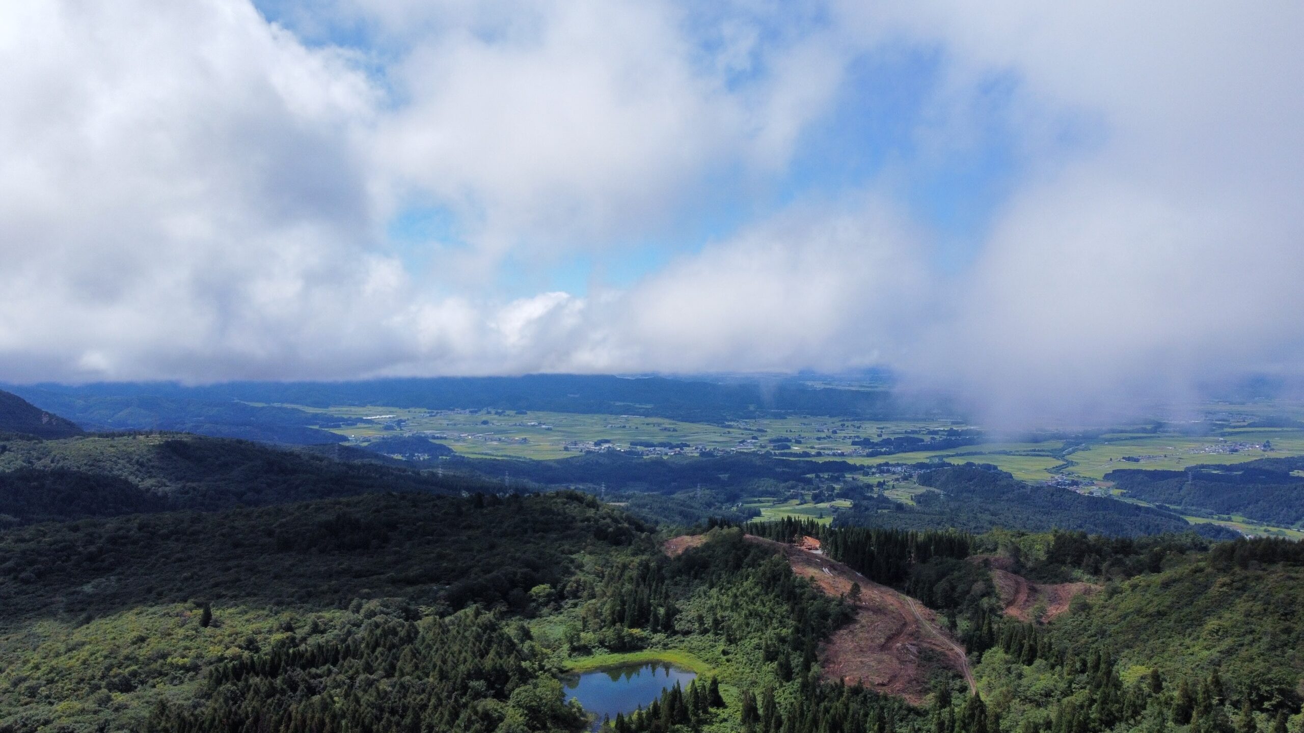
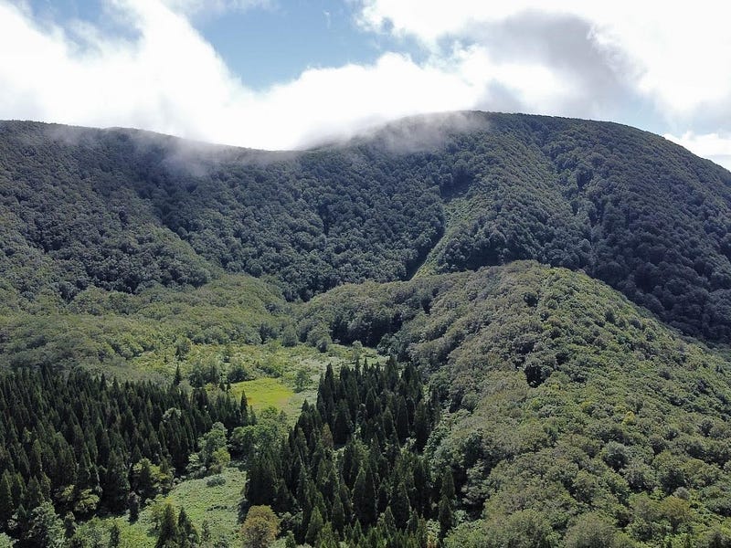
Okina-san is but one of the many peaks along the Ou Mountains, Japan’s longest mountain range stretching more than 500km from Fukushima in the south, all the way up to Aomori in the north. Okina-san is also part of the Prefectural Gosho-san Natural Park and at a height of 1,075m, its summit commands 360 degree panoramic views.
Not only a 100 Famous Mountain of Yamagata, the legendary Okina-san is also one of the 100 Famous Mountains of Tohoku. Over the centuries, Okina-san developed its own tradition of spiritual worship called ‘The Three Mountains of the East’, contrasting with the sacred Dewa Sanzan mountains lying to, you guessed it, the west.
Getting to Okina-san
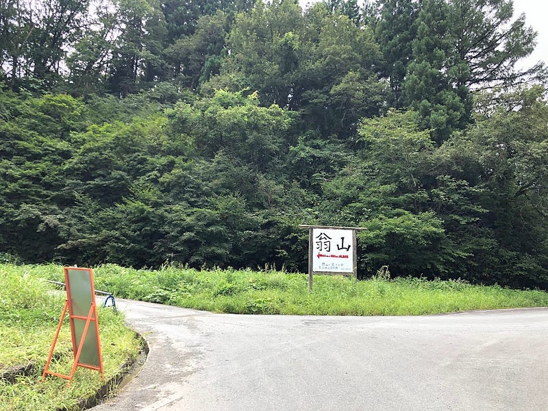
Okina-san and Okina-toge (mountain pass) are located along the borders of Yamagata and Miyagi Prefectures in Obanazawa City, behind the Myokenji rice terraces. On the way to the trailhead lies the Kurumi Daira pond known for its comet goldfish.
Put simply, Okina-san is difficult to reach. You are going to need a car, and it’s better if this car has 4WD, and a high ride height. This is because getting to Okina-san involves driving on a gravel road for at least 20 minutes, sometimes through untamed forests.

Once in the Myokoji hamlet, keep heading up the hills along the windy road. Before long, there will be a turn to the left. This road turns into gravel rather soon, and takes you past multiple construction and logging sites.
Keep following the road to the left where there is a fork, and past the Kurumi Daira pond (although you probably won’t notice it). Lastly, there is one final right turn along the narrow road until you make it to the Harima hut, Okina-San’s emergency hut.
Okina-san Direct Trail (90 minutes one-way)

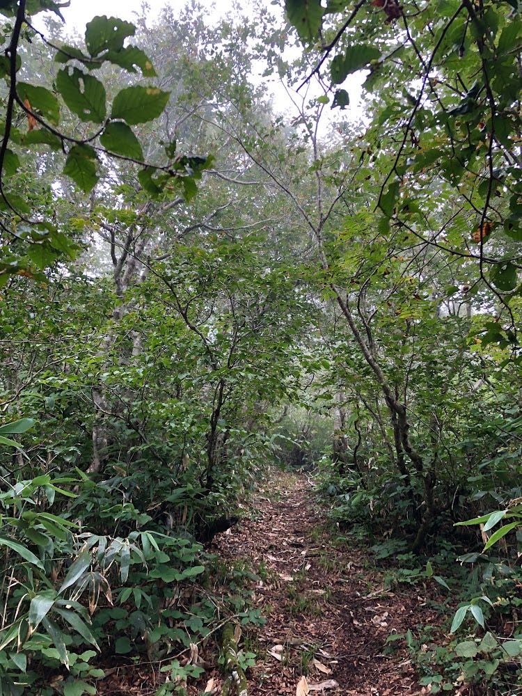
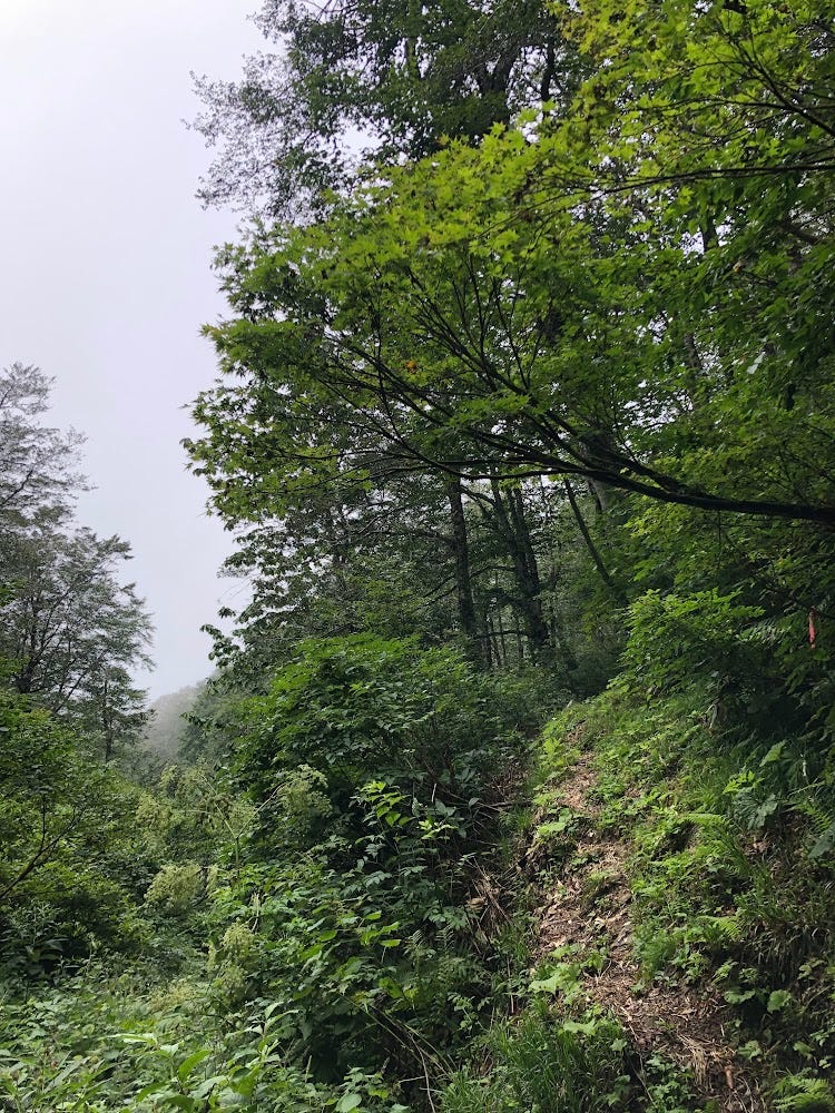
Okina-san’s trailhead is quite obvious once you reach the Harima hut. Keep following the path to the left at the first fork about five minutes in. The trail will take you through a beech forest, over small mountain streams, and along a final stretch through a forest of low bamboo shoots.
There are a few areas where extra care must be taken as the trail becomes very narrow, and very steep. And when I say steep, don’t just mean up and down. Sideways, as well. They say the trail is easy enough to bring kids on, although you would want to keep an eye on them for sure.
At the summit there is a small shrine and summit marker, and on fine days 360° views over Miyagi, inland Yamagata Prefecture, and to Gassan, Hayama, and many other famous mountains of Yamagata. Take the same trail back if you like, but since you’re already there, I would recommend going ahead and doing the Okina-san loop.
Okina-san loop (three hours all up)

To do the Okina-san loop, once you reach the summit, keep following the path straight. The return leg of the loop takes a similar amount of time as the way there. Since it’s primarily downhill, this makes doing the Okina-san loop a very good option, and is what I recommend. Simply keep following the trail straight from the summit.
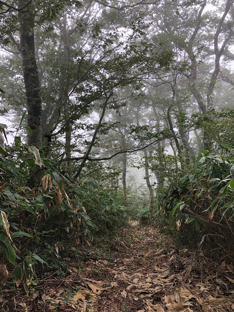
The low-lying bamboo area continues, and on fine days, you will be able to see pretty far from up here. Eventually, you will come across a fork in the road. Going straight will take you to Fukigoshi-yama and Dewa Toge, but taking a right into the beech forest will take you straight back to the Okina-san trailhead.
This last part of the path was rather treacherous, if I’m being honest. There were multiple ropes and it was very slippery a lot of the way. However, the mist was intense and the beech forest simply otherworldly to top it all off. Definitely worth visiting for your dose of Shinrinyoku.
Streams galore!
It was quite amazing to see, but when walking the trail, I noticed a few streams that just started in the middle of nowhere. As it so happens, this part of the trail was home to Furochoju-no-Izumi, the springs of longevity.
I was always perplexed as to how rivers started, besides just melted snow, and I guess I had found at least one answer. The water simply sprung out of the ground! Who would have guessed? These springs supposedly bring long life, and feed into many other streams nearby. Is it any wonder why Japan has the longest life expectancy in the world?
The White Deer and Venerable Old Man

From there, it is about another 20 or so minutes until you reach the fork in the road from earlier, and it’s just another 5 minutes to the Okina-san hut.
Right before the fork, there is a sign on the left hand side of the path that reads ‘did you come across the old man with white hair and the white deer? We hope to see you again!’
Unfortunately, I wasn’t able to see the two this time around, but I’m sure I’ll be up the mountain again sometime in the future. Needless to say, it was a great hike and I’d recommend Okina-san to anyone with the means to visit.
Nearby locations worth visiting
Ginzan Onsen
Okina-san is only a short 20 minute drive from Ginzan Onsen, one of the most well-known parts of Yamagata Prefecture. Famous for its Ryokan along a river that looks like they came straight out of a Ghibli film, Ginzan Onsen is an excellent location to relax after a few hours on the mountains of Yamagata.
Switch on coffee

One day I was passing through Obanazawa on my way home from Sendai and I found this awesome little cafe had only recently opened. They had amazing cheesecakes, and their selection of beans was something special.
Kita-yama

Kita-yama is the perfect spot for a picnic amongst the Sakura that offers panoramic views over the rice fields and mountains of inland Yamagata Prefecture.
Kamuro-dake
Kamuro-dake is a Mountain on the edge of a caldera on the borders of Mogami Town and the Onikobe part of Naruko Onsen, Miyagi Prefecture.
Futatsu-mori
Futatsu-mori is a distinctive twin-peaked mountain in Obanazawa City near the border with Miyagi Prefecture.
References
Yamakei Online (Japanese)
Yamagatayama.com (Japanese)
Yamap (Japanese)
Obanazawa City Website (Japanese)
OKINA-SAN
翁山 | おきなさん
Mt. Okina, Mt. Okina-san
Okina-san (翁山おきなさん) is a 1075m (3526 ft.) peak in the Mogami and Murayama regions of Yamagata prefecture open from mid-June to October. Okina-san is a level 2 in terms of physical demand, which means it is relatively easy to hike, has an A technical grade, which means it requires little expertise, and you want to allow at least 3 hours for a climb.
Mountain Range
Ou Mountains
Region
Murayama
Elevation
1075m (3526 ft.)
Technical Demand
A (requires little expertise)
Physical Demand
2 (relatively easy to hike)
Trails
1) Okina-san Direct Trail (90 minutes one-way)
Best time to climb
June to October
Day trip possible?
Yes
Minimum Time Required
3 hours
PDF Maps by TheHokkaidoCartographer and JapanWilds.org. See all here.


YAMABUSHI NEWSLETTER
KIWI YAMABUSHI

TIM BUNTING - KIWI YAMABUSHI